Improving daily precipitation estimations in a high mountainous watershed by developing a new downscaling method with spatially varying coefficients

Abstract
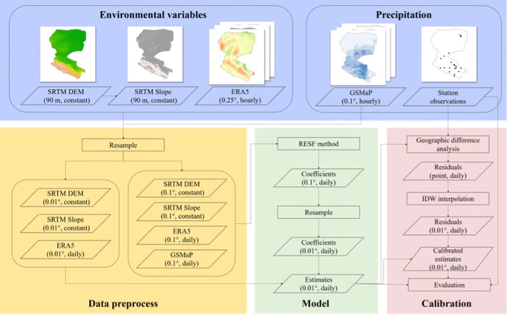
Accurate estimates of spatial patterns of daily precipitation are critically important for numerous hydrologic applications. However, the estimation of daily precipitation is still challenging, especially in regions with sparse observation networks and complex terrain. Although satellite precipitation products can offer continuous precipitation fields on a daily scale, the data contain large bias and coarse spatial resolution, which limit the application of these products in local studies. Here, we developed a new spatially varying coefficient downscaling approach to yield a daily precipitation field with high-resolution and high-accuracy in a high mountainous watershed. First, the random effect eigenvector spatial filtering (RESF) model was introduced and improved by considering the nonlinear term; second, the residuals were corrected by applying the simple inverse distance weighted (IDW) method. Using the proposed method, named RESF-IDW, the Global Satellite Mapping of Precipitation (GSMaP) was downscaled from 0.1° to 0.01° by integrating reanalyzed atmospheric data and environmental variables as auxiliary information. The performance of RESF-IDW was evaluated and compared with the geographically weighted regression (GWR) method and the original GSMaP precipitation products at 20 national and automatic stations by using leave-one-out cross validation. The results show that compared to the original GSMaP products, RESF-IDW, RESF, GWR-IDW, and GWR exhibited improvements in their mean values of correlation coefficient (CC) by 24.5%, 17.9%, 12.0%, and 3.2%, respectively. Additionally, their mean values of mean absolute error (MAE) improved by 31.2%, 14.9%, 18.7%, and 2.4%, respectively, while their mean values of root mean square error (RMSE) improved by 24.1%, 18.5%, 9.6%, and 3.8%, respectively. The RESF-IDW model can be used to correctly improve the original GSMaP product under different precipitation intensities, with critical success index (CSI) improvements of 38.81%, 43.14% and 44.58% for low, medium and high precipitation intensities, respectively. The use of residual correction enhances the spatial accuracy (MAE decreases by 19.43% on average) and the precipitation detection capability (CSI increases by 12.09% on average) of the RESF estimations. Based on the error metrics, the RESF-IDW model can be used to generate improved precipitation estimates on a daily scale and has a good capability for precipitation detection over different intensities. The proposed method in this study provides a promising way to generate accurate daily precipitation fields with high spatial resolution over data sparse and high mountain regions.