Evaluation and comparison of six high-resolution daily precipitation products in mainland China
Abstract
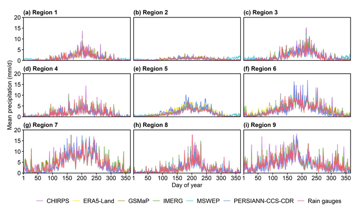
Satellite-based and reanalysis precipitation products have experienced increasing popularity in agricultural, hydrological and meteorological applications, but their accuracy is still uncertain in different areas. In this study, six frequently used high-resolution daily precipitation products, including Climate Hazards Group InfraRed Precipitation with Station data (CHIRPS), Global Satellite Mapping of Precipitation (GSMaP), Integrated Multi-satellitE Retrievals for Global Precipitation Measurement (IMERG), Multi-Source Weighted-Ensemble Precipitation (MSWEP), Precipitation Estimation from Remotely Sensed Information using Artificial Neural Networks-Cloud Classification System-Climate Data Record (PERSIANN-CCS-CDR) and European Center for Medium-Range Weather Forecasts Reanalysis V5-Land (ERA5-Land), were comprehensively evaluated and compared in nine regions of mainland China between 2015 and 2019. The results reveal that, in general, GSMaP is the best precipitation product in different agricultural regions, especially based on the Pearson correlation coefficient (CC) and critical success index (CSI). ERA5-Land and MSWEP tend to have the highest probability of detection (POD) values, and MSWEP tends to have the smallest relative root mean squared error (RRMSE) values. GSMaP performs better at almost all precipitation levels and in most agricultural regions in each season, while MSWEP has the best performance for capturing the time series of mean daily precipitation. In addition, all precipitation products perform better in summer and worse in winter, and they are more accurate in the eastern region. The findings of this study will contribute to understanding the uncertainties of precipitation products, improving product quality and guiding product selection.